Navigation


Rechercher

Accueil du site > Equipes de Recherche > Dynamiques foncières dans le district de Sing, province de Luang Namtha, RDP du Laos > Methodology
Methodology
Our research incorporates several interdisciplinary methods to understand the processes of land use transition and demographic change in Sing district. In particular, this study aims to incorporate spatial analysis and socio-economic analysis. We have used aggregated data on demography and agricultural production collected from local government offices, as well as primary field data collected in seven villages of Sing district during December 2003 and August 2005.
In order to understand the transitional state of land use and cover in Sing district over the previous decades we used Satellite data of Landsat between 1973 and 2004 to examine the overall land cover change. By using the maximum likelihood classification of the supervised classification, each Landsat image was classified into five categories including water, forest, shrub, open land (swidden), and paddy field. Furthermore, we selected three images from different time periods to assess land use change over the last decades. In order to understand the dynamic changes of forest cover, we investigated the patterns of forest fragmentation. This was done by converting all land use and land cover map into vector form and calculating the mean size and number of forest patches.
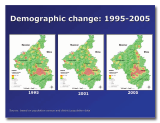 With regards to the demographic data, we used statistic obtained from the National Statistical Centre and the District Planning Office. Statistic from 1995, 2001, 2003, and 2005 were spatially registered to create population density maps to understand distribution of population and ethnic groups across the district, as well as trend of population movement in Sing district.
We also conducted interviews at the district agriculture and forestry office, and in four sub-districts to understand the history and events that led to population movements in the district. At the village level, we also conducted household interviews in seven villages in three sub-districts to understand local farmers’ own land use history, as well as their current land use practices. We interviewed members of village organizations in each of the seven villages to understand communal land use practices and local institutions for resource management, and how these were affected by government policies as well as the prevailing socio-economic environment. In addition to the spatial analysis, we incorporated socio-economic analysis by reviewing trends in agricultural production in Sing district, as well as household agricultural production in selected villages.
Dans la même rubrique :